AVIATION GPSA panel-style GPS navigator in your pocket
Aviation GPS turns your iPhone or Android phone into a panel-style GPS navigator. You get a moving map, RMI/HSI guidance, flight plans that sequence themselves, and a worldwide database of airports and navaids that works offline.
CONTENTS
01Introduction
Aviation GPS is laid out like a panel-mounted IFR GPS. The screen is split in two: navigation pages on top (map, CDI, HSI) and task pages underneath (flight plan, waypoint info, nearest, data fields, settings). Both halves are always visible, so you can edit a flight plan or look up a frequency without losing sight of the map.
Pilots who fly behind a panel-mounted GPS will find the workflow familiar: a 23-step map range table, a stepped declutter control, OBS mode, Direct-To, flight plan auto-sequencing and standard airspace messages. You can also simply use it as a large, easy-to-read moving map and nearest-airport finder.
Moving map
Airports, VOR/NDB, airspace, coastline, rivers, roads and cities, rendered offline worldwide.
Guidance
RMI, HSI with CDI, OBS mode, and a 3° visual-approach glidepath to any runway.
Flight plans
Build, reorder, reverse, save and load routes. Legs sequence automatically as you fly.
Airport info
Runways with a diagram, frequencies, elevation and live METAR/TAF.
Traffic
Optional internet traffic (OpenSky), or the simulator's own traffic when flying with X-Plane.
Track log
Records your flight in the background and exports it as CSV or GPX.
02Getting started
First launch
- Allow location access. The app needs your position for everything it does. Choose While Using the App (iPhone) or Allow only while using the app (Android). If you plan to use the track recorder with the screen locked, the phone will also ask for background location the first time you start a recording.
- Wait for the database to load. On launch the app reads its built-in database (about 55,000 airports, 10,000 navaids and 150,000 runways). A loading screen shows the progress. It usually takes a few seconds.
- Pick a destination. Tap the + button on the FPL page, or tap any airport on the map and press D→.
Screen layout
The main screen has four horizontal bands:
- Upper section: the navigation display. Its tab bar sits at the bottom of the section.
- Lower section: task pages. Its tab bar sits at the top of the section, so the two bars meet in the middle of the screen at a thin green divider.
- Status strip at the very bottom: app version, CPU load, and a red ● REC while the track recorder is running.
Tap a tab to show that page. The active tab is drawn solid green. MSG is always yellow because it isn't really a page: it opens the message pop-up (see Messages).
Your settings and active flight plan are saved automatically. You'll get them back the next time you open the app.
Colours & symbols
The colours mean the same thing on every page:
| Symbol | Meaning |
|---|---|
| Magenta disc with a white bar | Airport with a paved runway (the bar shows the direction of the longest runway) |
| Magenta ring | Grass, turf or dirt airfield |
| Magenta ring with "R" | Heliport |
| Magenta ring with × | Closed airport |
| Cyan hexagon | VOR (VOR-DME, VORTAC and TACAN have their own variants) |
| Dotted circle | NDB |
| Green × | User waypoint |
| White aircraft / triangle | Your position (choose the style under SET → POS SYMBOL) |
| Cyan dotted line | Breadcrumb trail of where you have flown |
| Arrowhead / diamond | Traffic (arrowhead points along its track; diamond if track unknown) |
Customising the tab bars
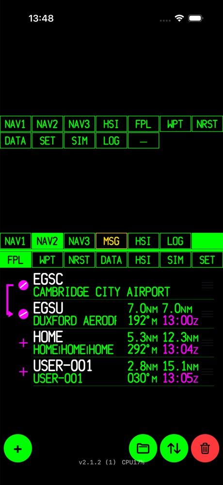
Every tab slot can be reassigned. Press and hold a tab for half a second. The slot blinks and a grid of every available page appears. Tap the page you want in that slot, or — to leave it empty. Tap any tab to cancel.
You can put the same page in both sections. For example, keep HSI on top and add a second map underneath. By default HSI is in both bars, so you can have the compass above a flight plan, or the map above an HSI.
| Default | Slots |
|---|---|
| Upper | NAV1 · NAV2 · NAV3 · MSG · HSI · LOG · (empty) |
| Lower | FPL · WPT · NRST · DATA · HSI · SIM · SET |
03Navigation pages
The upper section has four navigation displays. Each one shows the active leg as FROM → TO, for example EGSC → EGSU. During Direct-To it shows just the destination.
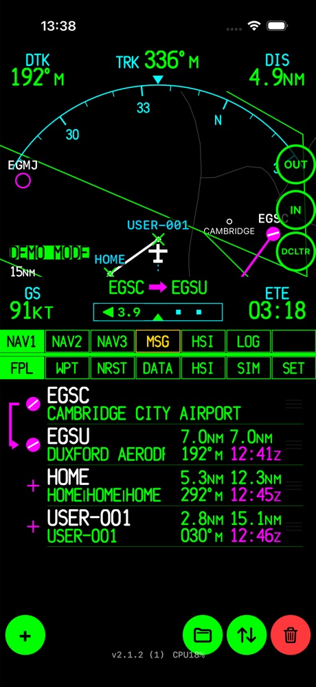
NAV1 — arc map
NAV1 shows a heading-up map under a cyan compass arc. Your aircraft sits near the bottom, so most of the screen shows what is ahead.
- Top row:
DTK(desired track), your currentTRKorHDGon the arc lubber line, andDISto the active waypoint. - Bottom row:
GS, the route label, a horizontal CDI bar, andETE. The number in the CDI is your cross-track error. The arrow shows which way to steer. - OUT / IN zoom the map. You can also pinch. The range (e.g.
15NM) is shown bottom-left. - DCLTR steps through the declutter levels (see Declutter).
- Long-press any of the four corner values to change what it shows.
The arc follows your GPS track when you're moving and the device compass when you're slow or stopped (see COMPASS REF in Settings).
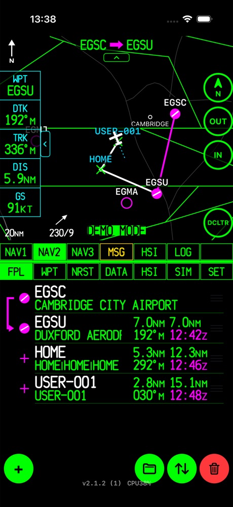
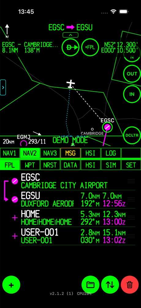
NAV2 — moving map
NAV2 is the full moving map, with a column of data fields down the left.
- Data column:
WPT,DTK,TRK,DIS,GSby default. Long-press a field to change it. Tap the small ‹ tab to slide the column away, and › to bring it back. - Orientation button (top right, labelled N): cycles NORTH UP → DTK UP → TRACK UP. If you've panned the map, the first tap re-centres it on your aircraft.
- Wind: the arrow and numbers at the bottom (e.g.
292/11) are the surface wind from the nearest METAR station, in degrees and knots. - Route header: the chevron under the FROM → TO label hides or shows that header.
NAV2 uses the full range table from 500 ft to 2000 NM. NAV1 uses a shorter list from 5 to 150 NM.
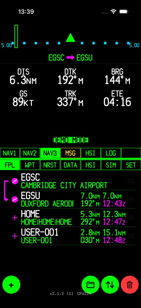
NAV3 — CDI page
NAV3 has no map, just big numbers that are easy to read in turbulence. At the top is a full-width course deviation indicator. The scale at each end (e.g. 5.00) is the full-scale deflection in NM. The triangle shows TO/FROM.
Under the route label are six data fields: DIS DTK BRG / GS TRK ETE by default. Long-press any of them to choose another value.
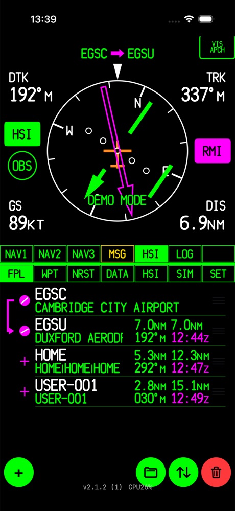
HSI — compass rose
The HSI page shows a full compass rose. Two independent pointers can be shown on it:
- HSI (green when on): a magenta course arrow set to the leg's DTK, with a deviation bar and dot scale. Like a real HSI, the bar moves away from the centre when you're off course.
- RMI (magenta when on): a bearing pointer aimed straight at the active waypoint, like an ADF/RMI needle.
Turn on one, the other, or both. The four corner fields (DTK TRK / GS DIS) can be changed with a long-press. Two more buttons are on this page: OBS and VIS APCH, covered in OBS & Visual Approach.
The compass card comes in two styles, GTN and B744 (SET → COMPASS STYLE).
04The moving map
Gestures
- Drag to pan. Tap the orientation button to re-centre.
- Pinch to zoom smoothly. When you let go, the range snaps to the nearest step in the table, so IN/OUT carry on from there.
- Tap an airport, navaid, airspace boundary or traffic target to see its details.
Tapping something on the map
An info bar opens across the top of the map with the ident and name, distance and bearing from you, and the coordinates. It has two buttons:
- D→ — fly Direct-To this point.
- +FPL — add it to the end of the flight plan.
Tap the name or coordinates in the info bar to open the full WPT page for that point.
Tapping an empty spot gives you a coordinate pop-up instead. From there you can add that position to the plan or save it as a user waypoint. If several airspace boundaries overlap where you tapped, the smallest one is shown first and you can step through the rest.
Range & AutoZoom
The range is the full width of the map from left to right. NAV2 steps through this range table: 500, 1000, 1500, 2000, 3500 ft; 1, 1.5, 2, 3.5, 5, 10, 15, 20, 35, 50, 100, 150, 200, 350, 500, 1000, 1500, 2000 NM. With NAV1 AUTOZOOM or NAV2 AUTOZOOM on, the map zooms in step by step as you approach the active waypoint, down to a minimum of 1 NM.
Declutter
Each press of DCLTR moves to the next level. The level is shown next to the range (e.g. 20NM-2) and the button turns solid green while any level is active.
| Level | What is removed |
|---|---|
| — | Everything shown (each category still has its own maximum range) |
| -1 | Roads, cities and traffic |
| -2 | Also airspace whose floor is more than 1,000 ft above your current altitude |
| -3 | All airspace |
| -4 | All airports and navaids except those in your flight plan |
Map layers
Each layer has its own on/off switch and maximum display range under SET → MAP, AIRSPACE and WAYPOINT RANGES. At busy ranges the app removes overlapping labels but never the symbols. Your flight plan and selected items get priority, then larger airports, then navaids.
- Sea/land, rivers, roads, cities: offline base map from Natural Earth.
- Airspace: worldwide boundaries from OpenAIP, grouped as B/TMA, C/TCA, D, Restricted/Danger/Prohibited, Military and Other. You can set the colour and line style of each group.
- Track line: an optional dashed line ahead of the aircraft along your ground track. It can show a fixed distance (TRK LINE DIST) or how far you'll get in a fixed time (TRK LINE TIME).
- Breadcrumb: the dotted trail of where you've been. You can clear it or save it as a file in SET.
- Traffic: see Traffic.
A navaid within 0.5 NM of an airport is hidden, because it's assumed to be that airport's own navaid. It does appear when you filter the NRST page to that navaid type.
Traffic
Turn traffic on under SET → TRAFFIC (off by default). Where it comes from depends on your GPS source:
- DEVICE GPS → OpenSky Network. Internet traffic collected by volunteer ground receivers. Reports are typically 5–20 s old, coverage depends on where receivers are, and aircraft without a Mode S/ADS-B transponder are missing. Between reports, targets are moved along their last known track so they don't jump.
- X-PLANE → simulator traffic (XTRAFFIC). This doesn't use the internet or any OpenSky quota.
An arrowhead points along the target's track. Above it is the relative altitude in hundreds of feet (e.g. +05), plus an arrow if it's climbing or descending faster than 500 fpm. Normal traffic is cyan, traffic on the ground is brown, a caution is amber (within 2 NM and ±1,200 ft, or a projected conflict within 45 s) and a warning is red (within 1.3 NM and ±1,200 ft, or within 25 s). Tap a target to see its callsign, type, squawk, altitude, speed and how old the report is.
05Direct-To
Direct-To draws a magenta course from where you are now straight to the chosen point. You can start it from:
- the D→ button in a map info bar,
- the D→ button on the WPT page. Any NRST result or flight-plan row opens there with one tap.
If a flight plan is active and the point isn't in it, the point is added to the end of the plan as a pending waypoint. It's listed on the FPL page, but no white route line is drawn to it. As soon as you activate any leg of the plan again, the pending flag is cleared and the plan carries on normally.
Tapping the DEST data field and choosing a waypoint works differently. It sets a new destination and suspends the active flight plan. To pick the plan up again, activate one of its legs on the WPT page (LEG→). Starting Direct-To or choosing a new destination also turns OBS off.
06Flight plans
The FPL page lists the active flight plan. Each row shows:
- the waypoint symbol, ident and name;
- leg distance and total distance from the start of the plan;
- the leg's DTK (magnetic);
- the ETA at your current groundspeed, in magenta. It's in UTC (
z) or local time, set under SET → FPL ETA.
The magenta bracket on the left marks the active leg, from the FROM waypoint to the TO waypoint.
Editing
| Tap a row | Opens that waypoint on the WPT page, where you can fly to it, activate that leg or remove it |
| Drag ≡ handle | Changes the order of waypoints |
| Swipe left | Deletes that waypoint |
| + | Adds a waypoint to the end (opens the search sheet) |
| Folder | Saved flight plans: SAVE / LOAD / DEL |
| ↑↓ | Reverses the whole plan (for the flight home) |
| Trash | Deletes the whole plan (asks first) |
Auto-sequencing
You don't need to touch anything as you fly the plan. The next leg activates automatically when you pass the active waypoint, which is detected in one of two ways: you enter a capture circle around it (bigger at higher groundspeeds), or your bearing to it shows you've passed abeam. Distances and ETAs then update for the new leg.
Saved flight plans
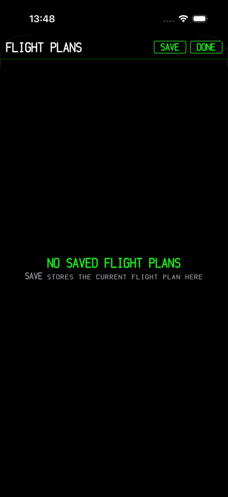
Tap the folder button to open the saved-plan catalogue.
- SAVE stores the current route under a name. Saving with a name that already exists replaces that plan.
- Tap a saved plan to LOAD it. It's loaded as a fresh copy with leg 1 active.
- DEL removes a saved plan.
Each saved plan is a separate file in the app's Documents folder, so it's included in your device backup. User waypoints used in a saved plan are never removed automatically.
07WPT — waypoint information
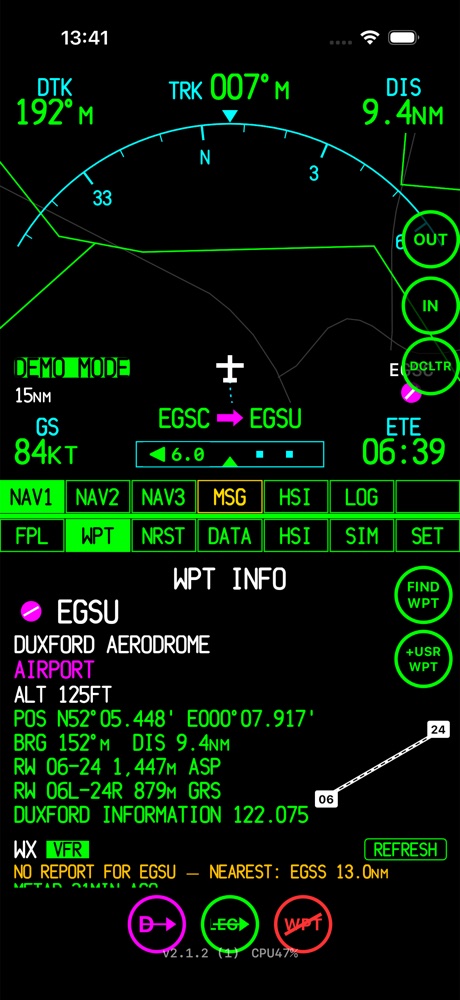
The WPT page shows everything the app knows about one waypoint. To open it, tap a row on the FPL or NRST page, tap the info bar on the map, or use FIND WPT. The page keeps showing that waypoint when you switch to other pages and come back.
- Ident, name and type (AIRPORT, HELIPORT, VOR, NDB, WPT…).
- Elevation and position in your chosen coordinate format.
- Bearing and distance from your current position.
- Runways with length and surface (ASP, GRS, CON…), plus a small runway diagram.
- Frequencies (ATIS, TWR, INFO, …).
- WX: flight-category badge (VFR / MVFR / IFR / LIFR), the latest METAR and its age, and the TAF. Tap REFRESH to update.
Buttons
| D→ | Fly Direct-To this waypoint |
| LEG→ | Activate the flight-plan leg to this waypoint (only for waypoints in the plan) |
| WPT (crossed) | Remove this waypoint from the flight plan |
| FIND WPT | Look up any waypoint without adding it to the plan |
| +USR WPT | Save your current position as a user waypoint |
| EDIT / RENAME / DEL | Shown for saved user waypoints |
08Search & user waypoints
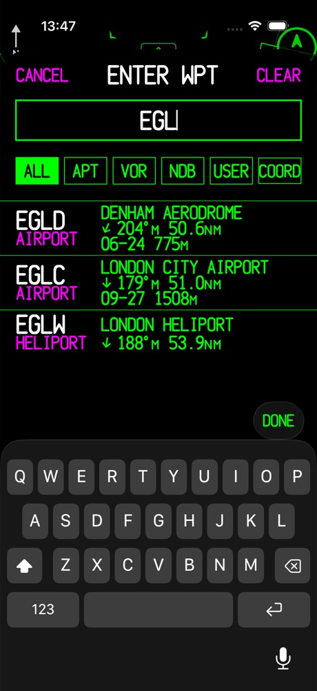
The ENTER WPT sheet opens whenever you need to choose a waypoint: + on the FPL page, tapping the DEST field, or FIND WPT.
- Type an ident or a name. Results update as you type.
- Filter with ALL APT VOR NDB USER, or switch to COORD to enter a latitude/longitude.
- Each result shows its type, a bearing arrow, the magnetic bearing and distance, and the longest runway.
- Results are sorted nearest first or alphabetically (SET → SEARCH SORT).
- CLEAR empties the search box. CANCEL closes the sheet without choosing anything.
Under SET → SEARCH & DATABASE you can choose whether national-format idents (e.g. GB-0401), other-format idents (e.g. 00A), navaids and closed airports are included. HIDDEN means they don't show in normal results but are still found if you type their exact ident.
User waypoints
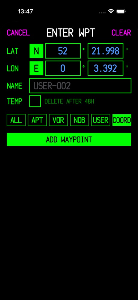
The COORD tab creates your own waypoints:
- Enter the latitude and longitude. Tap N/S and E/W to switch hemisphere. When a field is full, the cursor moves to the next one. The fields match your POSITION FRMT setting (DEG, D M or DMS).
- Give it a name, or keep the suggested
USER-nnn. - Tick TEMP if it should be deleted automatically after 48 hours.
- Tap ADD WAYPOINT.
Other ways to create a user waypoint: +USR WPT on the WPT page (your current position), or tap an empty spot on the map. Saved waypoints show in the USER filter. That list is also where you manage them: temporary waypoints have a TEMP badge with the hours left, and DEL removes one.
09NRST — nearest
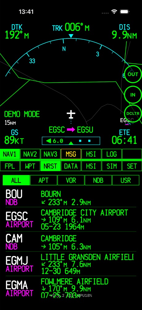
NRST lists everything near you, closest first, and updates as you fly. The filter row narrows the list to ALL, APT, VOR, NDB or USR.
Each entry shows the ident and type, the name, a bearing arrow relative to your track, the magnetic bearing and distance, and for airports the longest runway and its length.
While a filter is active, the map shows every match even where it would normally be hidden by its display range, so you can see where the nearest NDB is at a glance.
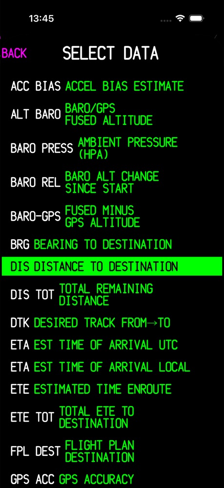
10DATA page & data fields
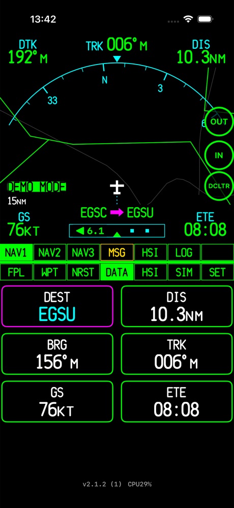
The DATA page shows six large data fields in a 2×3 grid. The defaults are DEST, ETE, VS, ETA, POS and ALT.
- Tap the
DESTfield (outlined in magenta) to search for a new destination (see Direct-To). - Tap any other field to open the SELECT DATA list. Tap the value you want. BACK leaves it unchanged.
On the other pages, long-press a field to change it. That works on the NAV1 corner fields, the NAV2 data column, the NAV3 grid and the HSI corner fields. SET → LOAD DEFAULT DATA FIELDS puts every field back to its default.
Available fields
| Field | Shows |
|---|---|
| DEST | Destination identifier |
| DIS | Distance to destination |
| BRG | Bearing to destination |
| DTK | Desired track, FROM → TO |
| TRK | GPS track over the ground |
| HDG | Device magnetic heading (compass) |
| HDG/TRK AUTO | Heading when slow, track when moving |
| XTK | Cross-track error |
| TKE | Track angle error |
| ROT | Rate of turn |
| GS | Groundspeed |
| ETE | Time en route to destination |
| ETA | Estimated time of arrival (UTC or local versions) |
| TIME / UTC | Current local or UTC time |
| ALT | GPS altitude |
| VS | Vertical speed (fpm) |
| VSR | Vertical speed required to arrive at destination elevation +1,000 ft |
| POS | Current position |
| MAG VAR | Magnetic variation (WMM2025) |
| GPS ACC | Reported GPS accuracy |
| FPL DEST | Last waypoint of the flight plan |
| DIS TOT / ETE TOT | Distance and time remaining to the end of the plan |
| LEG | Active flight-plan leg |
| ALT BARO, VS BARO, VS GPS, BARO PRESS, BARO REL, BARO-GPS, VS INRT, ACC BIAS | Barometer and accelerometer diagnostics. Useful for comparing the sensor sources in flight. |
| OFF | Field disabled |
11OBS & Visual Approach
OBS mode
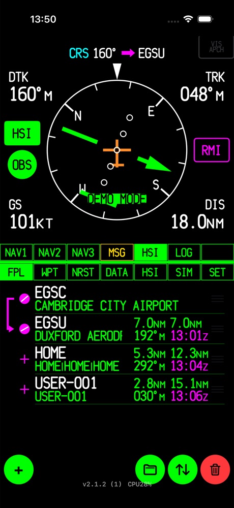
OBS lets you fly a course of your choice to or from the active waypoint, as you would with a VOR radial. On the HSI page:
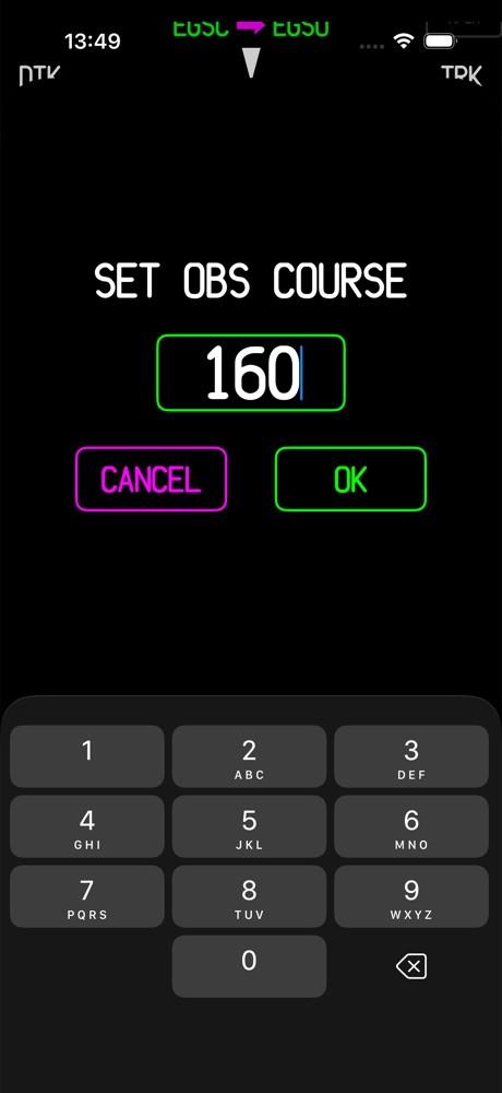
- Tap OBS. A keypad opens with the current DTK filled in.
- Type the course and tap OK.
- The route header changes to
CRS 160° → EGSUand the HSI follows that course.
You can also drag the OBS button up or down to dial the course. Tap OBS again to turn it off. The app remembers the course you used last time.
While OBS is on, the map hides the flight plan and draws a single line through the waypoint: magenta on the inbound side and white beyond it. The CDI is also made less sensitive (one third), like a VOR display.
Visual Approach
Visual Approach gives you an extended runway centreline and a 3° glidepath to a runway you choose. It's meant as a cross-check on visual approaches where there's no ILS. The VIS APCH button on the HSI page becomes available when:
- your destination is an airport with runway data, and
- you are within 15 NM of it.
Tap it and pick the runway end you're landing on. Each runway is listed once in each direction with its length and surface. The HSI then shows the lateral deviation from the centreline plus a glidepath needle. Tap VIS APCH again to cancel. Visual Approach and OBS can't both be on: turning one on turns the other off.
12Messages & airspace alarms
The MSG tab opens the message pop-up. When there's a new message the button flashes yellow. Tap MSG again (or tap the pop-up) to close it.
The app checks airspace within 15 NM of you, at any map zoom, and shows these messages:
| AIRSPACE AHEAD -- LESS THAN 10 MINUTES | Your current track enters airspace within 10 minutes |
| AIRSPACE NEAR AND AHEAD | Ahead and less than 2 NM away |
| NEAR AIRSPACE LESS THAN 2NM | Close by, but not on your track |
| INSIDE AIRSPACE | You're inside the boundary |
The most serious messages are listed first. With AUTO MSG on, the pop-up opens by itself and closes after a countdown. AUDIBLE MSG ALERT plays a tone as well. An airspace group you've switched off on the map won't trigger alarms either.
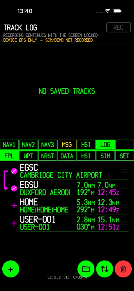
13Track log
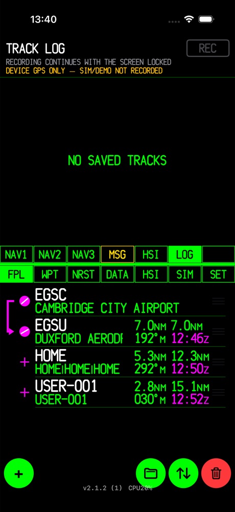
The LOG page records your flight:
- Tap REC to start and again to stop. While it's recording, a red ● REC shows in the status strip on every page.
- Recording carries on with the screen locked, so the phone can stay in your pocket.
- Each position is written to the file straight away, so if the app crashes or the battery dies you lose at most one point.
- Past flights are listed with CSV and GPX share buttons. Use the phone's share menu to send them to Files, AirDrop or Nearby Share, email, or a logbook app.
To keep files small, a point is saved at most once a second, and only after you've moved 25 m or 15 s have passed. Fixes worse than 100 m accuracy are skipped.
14SIM page, Demo mode & X-Plane
Demo mode
SET → DEMO MODE has three options:
- OFF — normal operation.
- GPX TRACK — replays a recorded flight over and over. Good for exploring the app or showing it to someone on the ground.
- SIM — you fly the aircraft from the SIM page.
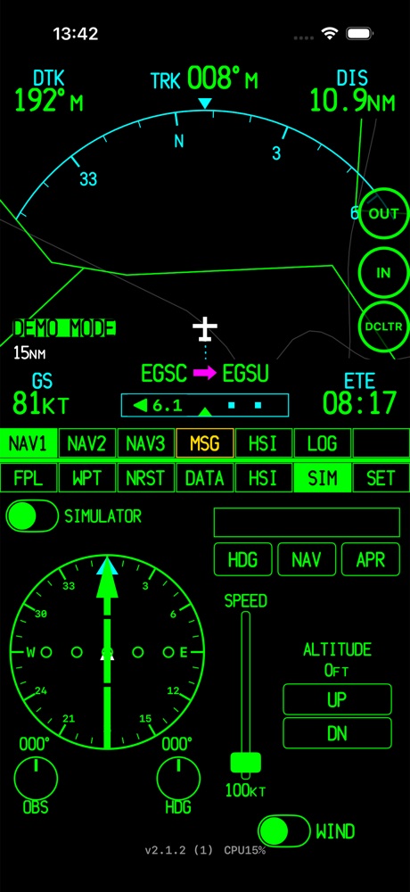
SIM page
The SIM page has a simple instrument panel for flying the built-in simulator:
- SIMULATOR switch — turns SIM mode on or off directly from this page.
- HSI with an OBS knob and a HDG bug knob.
- Autopilot modes HDG (fly the heading bug), NAV (follow the GPS course, turning onto the next leg in good time) and APR (NAV with a tighter CDI). The display above the buttons shows ARM while the course is being intercepted and CPLD once it's captured.
- SPEED lever and ALTITUDE UP/DN (100 ft steps).
- WIND — adds real forecast winds at your altitude, so the simulated aircraft drifts and has to crab.
In SIM mode you can also drag the aircraft symbol on the NAV2 map to move it somewhere else.
Using with X-Plane
- Connect your phone and the X-Plane computer to the same Wi-Fi network.
- In X-Plane, open Settings → Network and turn on Broadcast to 3rd-party apps (it uses UDP port 49002).
- In Aviation GPS, set SET → GPS SOURCE to X-PLANE.
- For traffic, turn on SET → TRAFFIC. X-Plane's AI aircraft then show on the map with no internet needed.
If no traffic shows up, the TRAFFIC row in SET tells you why: NO XTRAFFIC RECEIVED (X-Plane isn't sending traffic), XTRAFFIC NOT USABLE (data arrives but can't be read), or NO SIM TRAFFIC (it's working, but no aircraft are flying near you).
15Settings reference
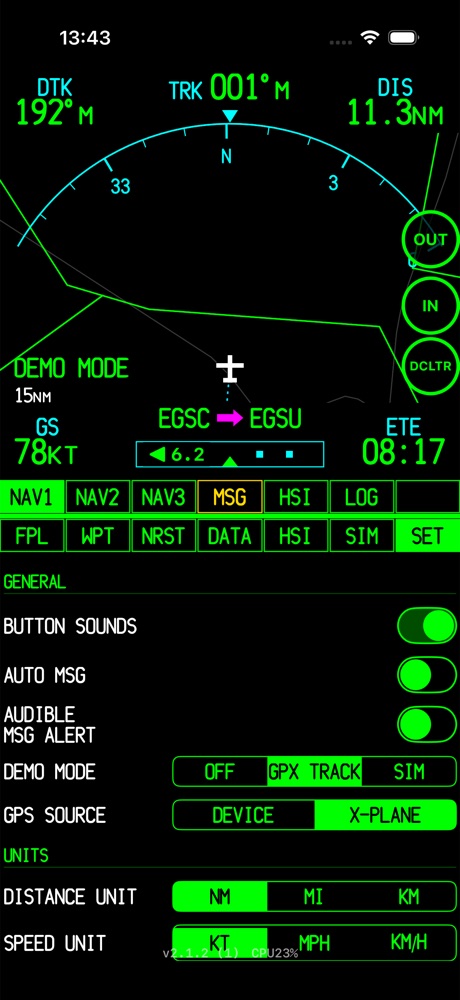
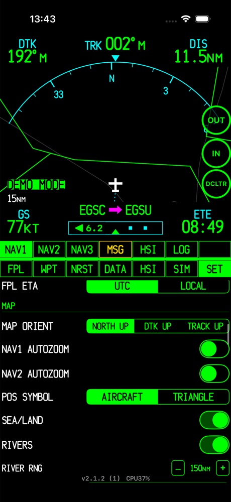
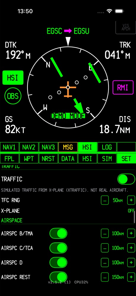
Everything is on the SET page, grouped into sections. Changes take effect straight away and are saved when you leave the page or the app. Defaults are shown in bold.
General
| Setting | Options | What it does |
|---|---|---|
| BUTTON SOUNDS | On / Off | Click sound when you press a button |
| AUTO MSG | On / Off | Opens the message pop-up automatically for new alarms |
| AUDIBLE MSG ALERT | On / Off | Plays a tone for new messages |
| DEMO MODE | OFF / GPX TRACK / SIM | Simulated position (see SIM & Demo) |
| GPS SOURCE | DEVICE / X-PLANE | Use the phone's GPS or X-Plane's broadcast |
Units
| Setting | Options |
|---|---|
| DISTANCE UNIT | NM / MI / KM |
| SPEED UNIT | KT / MPH / KM/H |
| ALTITUDE UNIT | FT / M |
| RUNWAY UNIT | FT / M |
| POSITION FRMT | DEG (hddd.ddddd°) / D M (hddd°mm.mmm', the default) / DMS (hddd°mm'ss.s"). Used for both display and entry. |
| FPL ETA | UTC / LOCAL |
Map
| Setting | Options | What it does |
|---|---|---|
| MAP ORIENT | NORTH UP / DTK UP / TRACK UP | NAV2 map orientation (also changed by the on-map button) |
| NAV1 / NAV2 AUTOZOOM | On / Off | Zooms in automatically as you approach the waypoint |
| POS SYMBOL | AIRCRAFT / TRIANGLE | Own-ship symbol |
| SEA/LAND | On / Off | Coastline and water shading |
| RIVERS · RIVER RNG | On · 150 NM | Rivers and the maximum range they're shown at |
| ROADS · ROAD RNG | OFF / FRWY / FR+HW / ALL · 350 NM | Which road classes are drawn |
| CITIES · CITY RNG | OFF / LRG / LRG+MED / ALL · 1000 NM | Which city sizes are drawn |
| FPL LINE RNG | 2000 NM | Maximum range for route lines |
| TRACK LINE | OFF / DIST / TIME | Dashed line ahead along your track. TRK LINE DIST (default 10 NM) or TRK LINE TIME (default 10 min). |
| BREADCRUMB | On / Off · CLEAR · SAVE | Shows the trail of where you've flown. SAVE exports it, CLEAR erases it. |
Traffic
| Setting | Default | What it does |
|---|---|---|
| TRAFFIC | Off | Shows traffic on the map (OpenSky or X-Plane, depending on GPS SOURCE) |
| TFC RNG | 50 NM | Traffic is hidden when the map is zoomed out wider than this |
| TFC UPDATE | 30 s | How often OpenSky is checked (DEVICE source only) |
| OPENSKY ACCOUNT… | Anonymous | Optional free OpenSky API login. Anonymous use allows 400 requests a day per network; with an account you get 4,000. The row shows how many are left. |
Airspace
| Setting | Default | What it does |
|---|---|---|
| AIRSPC B/TMA | On · 100 NM | Turns each airspace group on or off and sets the widest map range it's shown at |
| AIRSPC C/TCA | On · 100 NM | |
| AIRSPC D | On · 100 NM | |
| AIRSPC REST | On · 150 NM | |
| AIRSPC MIL | On · 150 NM | |
| AIRSPC OTHER | Off · 35 NM | |
| HIDE AIRSPC ABOVE | 10,000 ft | Never draws airspace whose floor is above this altitude |
| AIRSPACE COLORS / LINE STYLES… | All green, solid | Colour and line style for each group, plus which groups trigger alarms |
Waypoint ranges
The widest map range at which each kind of waypoint is still drawn:
| Category | Default |
|---|---|
| ACTIVE FPL | 2000 NM |
| LARGE APT | 150 NM |
| MEDIUM APT | 50 NM |
| SMALL APT | 20 NM |
| INT | 10 NM |
| NDB | 10 NM |
| VOR | 150 NM |
| USER | 150 NM |
Navigation
| Setting | Options | What it does |
|---|---|---|
| COMPASS REF | AUTO / TRK / HDG | What the compass displays turn to. AUTO uses the device heading when slow and GPS track when moving. |
| AUTO HDG/TRK AT | 3 / 10 / 30 KT | The groundspeed at which AUTO changes from heading to track |
| HSI CDI SENSITIVITY | AUTO / 5 / 1 / 0.3 NM | Full-scale deflection of the CDI |
| COMPASS STYLE | GTN / B744 | How the compass card looks |
| BARO FUSION | On / Off | Combines the phone's barometer with GPS for smoother altitude and vertical speed (device GPS only) |
| INERTIAL VS | On / Off | Also uses the accelerometer so vertical speed reacts faster. Experimental: prolonged turns can affect it. |
| GPS SMOOTHING | OFF / LOW / MED / HIGH | Smooths out GPS jitter in your position. HIGH is smoothest but can lag in long turns, so it suits cruise best. |
| MIN VS DISPLAY | 5 / 25 / 50 FPM | Vertical speeds smaller than this show as zero |
| ROUND VS TO | EXACT / 50 / 100 FT | Rounding for vertical speed |
| ROUND GPS ALT | EXACT / 10 / 100 FT | Rounding for GPS altitude |
Data fields
| MAP DATA FLDS | Shows or hides the NAV2 data column |
| HSI DATAFIELDS | Shows or hides the four corner fields on the HSI page (On) |
Search & database
| Setting | Options | What it does |
|---|---|---|
| SEARCH SORT | NRST / ALPHA | Order of search results |
| AIRPORT TYPES | ALL / APT ONLY / HEL ONLY | Airports, heliports, or both |
| USE NATL APTS | NO / HIDDEN / YES | National-format idents such as GB-0401 |
| USE OTHER APTS | NO / HIDDEN / YES | Other formats such as 00A |
| USE NAVAIDS | NO / HIDDEN / YES | VOR, NDB and other navaids |
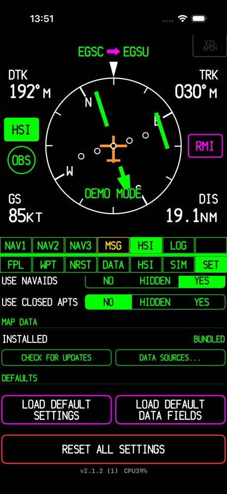
| USE CLOSED APTS | NO / HIDDEN / YES | Closed airfields |
HIDDEN: left out of nearest lists and normal search results, but still found when you type the exact ident.
Map data
INSTALLED shows which version of the map data you have (BUNDLED is the copy that came with the app). CHECK FOR UPDATES downloads newer airport, airspace and base-map data. It only runs when you tap it, never automatically. DATA SOURCES… lists where each data layer comes from and its version.
Defaults
- LOAD DEFAULT SETTINGS — puts every setting back to its default.
- LOAD DEFAULT DATA FIELDS — puts only the data-field choices back to their defaults.
- RESET ALL SETTINGS — factory reset, asks first. Your saved waypoints, active flight plan and breadcrumb trail are kept.
16Data, connectivity & privacy
What works offline
The moving map, the airport/navaid/runway/frequency database, airspace, flight planning, nearest search, guidance, magnetic variation and track recording all work with no internet connection. Only these need data:
| Feature | Source | Notes |
|---|---|---|
| METAR / TAF | aviationweather.gov | Cached for 10 minutes, and the last report stays on screen if you lose signal |
| Map wind arrow | aviationweather.gov (nearest METAR) | Updated when you've moved a meaningful distance or time has passed |
| Internet traffic | OpenSky Network | Off by default; daily request limit |
| SIM winds aloft | Open-Meteo | Only used by the SIM page's WIND option |
| Map data updates | OurAirports, OpenAIP, Natural Earth | Only when you tap the button. Files are checked for integrity before they replace the old ones. |
Databases
- Airports, runways, frequencies, navaids: OurAirports (public domain).
- Airspace: OpenAIP.
- Coastline, rivers, roads, cities: Natural Earth (public domain).
- Magnetic variation: NOAA/BGS World Magnetic Model WMM2025, valid 2025–2030, calculated on the device.
Privacy
Aviation GPS has no account, no server of its own and no analytics. Your position never leaves the device, with one exception: weather and traffic requests include a box around your approximate position so the services know what area to return. Flight plans, user waypoints and track logs are stored only on your device.
17Troubleshooting
| Problem | What to check |
|---|---|
| NO GPS FIX | Check that location access is allowed for Aviation GPS: on iPhone in Settings → Privacy & Security → Location Services; on Android in Settings → Apps → Aviation GPS → Permissions → Location. Inside a building or a metal fuselage reception can be poor; try near a window. |
| Map heading is wrong on the ground | When you're slow, the display uses the phone's compass, which is disturbed by the aircraft's metal and electrics. It switches to GPS track above the AUTO HDG/TRK AT speed. |
| A small airfield is missing | Check SET → USE NATL APTS / USE OTHER APTS. Some airfields only have a national-format ident and are HIDDEN by default. Type the exact ident, or set the option to YES. |
| An NDB/VOR doesn't show on the map | It may be hidden by its waypoint range at the current zoom, or by declutter level ‑4. A navaid on an airfield is shown as part of the airport. |
| No traffic | TRAFFIC must be on, the declutter level must be "—", and the map must be zoomed in to TFC RNG or less. For OpenSky, check the requests left in the TRAFFIC row. For X-Plane, read the status shown there. |
| VIS APCH is greyed out | The destination has to be an airport with runway data, and you have to be within 15 NM of it. |
| REC button is disabled | The track recorder only works with DEVICE GPS and Demo mode OFF. |
| Weather says "NO REPORT FOR …" | That airfield doesn't publish a METAR. The app is showing the nearest station's report instead. |
| Map data update failed | Your existing data is never touched until a new download has finished and been checked. Try again with a better connection. |